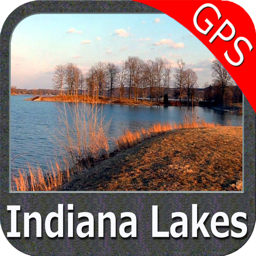
Features Indiana Lakes GPS Charts
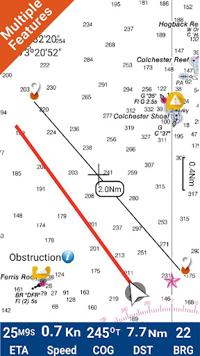
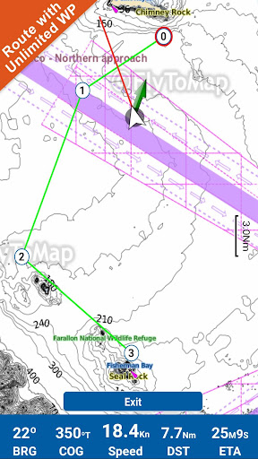
Flytomap is a valid and interesting alternative, Featured on the DeckFeatured on GeomediaWorldwide Marine and Outdoor Maps available when connected, thanks to viewer.flytomap.comWorldwide Satellite images overlay on charts Worldwide Terrain features overlay on charts, thanks to Open Street Map, Open Cycle Map,Earth,topo maps by ESRINow with NOAA raster charts seamless with continuous updates from the official Government serverNow with ActiveCaptain - Worldwide boaters community * 200.000 + CaptainsUse to Explore: √ Latitudes and Longitudes to go to your favorite places √ Search your Favorite points directly √ Zoom, Rotate and Pan fast just by a finger touch√ Route with unlimited waypoints√ With Head Up and Course Up feature√ Geocompass √ Navigate and see your GPS position on the map √ Heading Vector Towards the direction movement √ Distance Measurement Tool to easily calculate the distance from one location to another √ Insert the target/destination and see in real time your speed, distance and bearing √ background mode - Flytomap works in background as well, you can swap with another app and receive/make calls send sms while panning and zooming.√ Unlimited Tracks share via email, visible on Google, Flytomap Viewer, KMZ format - Store your track without the need of cellular data or mobile signal√ KMZ KML from / to GPX Converter√ Optimized battery usage√ ActiveCaptain• View and contribute to the best boaters community available in the world • Continuous update of all info (including reviews from the deck) about :• Marinas• Anchorages• Hazards• Local Knowledge√ And so much more to come - It’s the only app you will ever need!
Our charts are installed on: NAVICO LOWRANCE B&G NORTHSTAR EAGLE SIMRADFollow us:▶Twitter @flytomap▶Web Site flytomap.com ▶Web App viewer.flytomap.com▶Facebook facebook.com/flytomapThe entire cartography of Indiana Lakes is included in this applicationADAMS LAKEAPPLEMAN LAKEATTWOOD LAKEBANNING LAKEBASS LAKEBEAR LAKEBIG LAKEBIG LONG LAKEBLACK CAT LAKEBLUEGRASS LAKEBROKESHA LAKECASS LAKECEDAR LAKECLEAR LAKECREE LAKECROOKED LAKEDALE LAKEDEWART LAKEDUCK LAKEEMMA LAKEEVERETT LAKEFLINT LAKEGAGE LAKEGILBERT LAKEGRAVEYARD LAKEGREEN LAKEGRIFFY LAKEHACKENBERG LAKEHEATON LAKEHENRY LAKEHILL LAKEHINDMAN LAKEHUDSON LAKEHUNTINGBURG LAKEINDIAN LAKEJONES LAKEKOONTZ LAKEKUHN LAKELAKE OF THE WOODSLATTA LAKELIME LAKELINDSEY LAKELITTLE BARBEE LAKELITTLE OTTER LAKELITTLE PIKE LAKELITTLE TURKEY LAKELOOMIS LAKELOON LAKEMCCLURES LAKEMESERVE LAKEMESSICK LAKEMETEER LAKEMUD LAKENAUVOO LAKENORTH LITTLE LAKENYONA LAKEOTTER LAKEPIKE LAKEPLEASANT LAKEPRETTY LAKERIDDLES LAKERIDER PONDROBINSON LAKEROUND LAKESHIPSHEWANA LAKESILVER LAKESIMONTON LAKESOUTH MUD LAKESTARVE HOLLOW LAKESTEINBARGER LAKESTONE LAKETAMARACK LAKETAYLOR LAKETHOMAS LAKEUPPER LONG LAKEWALDRON LAKEWALL LAKEWAUBEE LAKEWAVELAND LAKEWEST BOGGS LAKEWEST LAKEWEST OTTER LAKEWESTLER LAKEWITMER LAKEYELLOWWOOD LAKEFlytomap is committed to constant improvement, this App is developed with the help of professional boaters to get the best experience on the sea, we listen to our users and systematically add the most requested features.
Thank you for the feedback!Additional info about Flytomap productsFLYTOMAP LAKE MAPS:We offer high quality lake maps with detailed information and important features compressed to assure the larger coverage in USA region.
Lake maps contain most important DNR lakes with detailed ‘Depth Contours, Boat Ramps, Fishing spots etc.
Also includes Trails, Roads and Railways information.“We work to delight your moments”!
Enjoy great Journeys!
Social Features
Connect and share with friends and the community.
Fitness Tracking
Track your workouts and monitor your health metrics.
Productivity Tools
Boost your productivity with powerful tools and features.
See the Indiana Lakes GPS Charts in Action

Get the App Today
Available for Android 8.0 and above